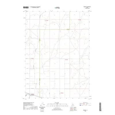
2020 Map of Minidoka
USGS Topo · Published 2020About this map
Minidoka serves as the primary focal point in this southern Idaho landscape, located at the intersection of several local thoroughfares. The settlement pattern is defined by a grid of agricultural and connector roads, including Broadway St, Cherry St, and N 900 E. Extending north from the town, the Minidoka to Arco Rd and Arco Rd indicate long-standing transport routes through the high desert, while the Minidoka Co Blaine Co boundary line bisects the territory. This map documents a region where the human imprint is sparse but deliberate, centered on the transit and logistics that historically supported the local ranching or agricultural economy. The surrounding terrain is primarily surveyed through the Public Land Survey System, with township and range lines like t7s r25e and t7s r26e providing the structural framework for the land's organization.
Find a feature on this map
19 named features on this map. Tap any name to fly to it.
Don’t see what you’re looking for? This feature index may not catch every label — zoom into the map to look around manually.
Map Details
Editions of this 2020 Minidoka Map
This is the sole edition of this map. No revisions or reprints were ever made.
Other maps of this area

1954 · Pocatello
USGS Topo · 1:250,000

1958 · Pocatello
USGS Topo · 1:250,000

1959 · Lake Walcott
USGS Topo · 1:62,500

1964 · Acequia
USGS Topo · 1:24,000

1972 · Schodde Well
USGS Topo · 1:24,000

1972 · Bear Trap Cave
USGS Topo · 1:24,000

1972 · Minidoka
USGS Topo · 1:24,000

1972 · Max
USGS Topo · 1:24,000
1972 · Brigham Point
USGS Topo · 1:24,000
1972 · Larkspur Park
USGS Topo · 1:24,000