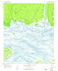
1943 Map of Minim Island
USGS Topo · Published 1962About this map
The complex tidal delta of the Santee River system dominates this 1943 survey, where the North Santee River and South Santee River split to reach the Atlantic. This coastal landscape is marked by its deep agricultural history, specifically the transition of former rice-growing estates into the mid-20th century. Several prominent tracts are preserved in name, including Rice Hope Plantation, Doar Plantation, Kinloch Plantation, and Annandale Plantation, clustered along the northern edge of the Santee Swamp.
Find a feature on this map
47 named features on this map. Tap any name to fly to it.
Don’t see what you’re looking for? This feature index may not catch every label — zoom into the map to look around manually.
Map Details
Editions of this 1943 Minim Island Map
5 editions found
Other maps of this area

1942 · Cape Romain
USGS Topo · 1:24,000

1942 · Mc Clellanville
USGS Topo · 1:24,000

1942 · Santee Point
USGS Topo · 1:24,000

1942 · North Island
USGS Topo · 1:24,000

1943 · Kilsock Bay
USGS Topo · 1:24,000

1943 · Santee
USGS Topo · 1:24,000

1943 · Minim Island
USGS Topo · 1:24,000

1943 · Georgetown South
USGS Topo · 1:24,000

1947 · Georgetown South
USGS Topo · 1:24,000

1949 · Georgetown
USGS Topo · 1:250,000