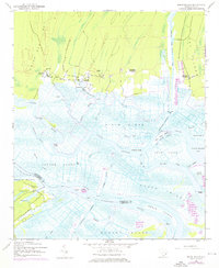
1943 Map of Minim Island
USGS Topo · Published 1976About this map
Historic rice culture and the intricate hydrology of the Lowcountry define this landscape where the North Santee River and South Santee River approach the Atlantic. The presence of several large estates, including Rice Hope Plantation, Kinloch Plantation, and Annandale Plantation, reflects the region's long-standing agricultural focus and the complex system of canals and ditches required to manage these riverine wetlands. Local life centered on these plantations is further evidenced by landmarks like Rice Hope Ch and Bethel Ch.
Find a feature on this map
47 named features on this map. Tap any name to fly to it.
Don’t see what you’re looking for? This feature index may not catch every label — zoom into the map to look around manually.
Map Details
Editions of this 1943 Minim Island Map
5 editions found
Other maps of this area

1942 · Cape Romain
USGS Topo · 1:24,000

1942 · Mc Clellanville
USGS Topo · 1:24,000

1942 · Santee Point
USGS Topo · 1:24,000

1942 · North Island
USGS Topo · 1:24,000

1943 · Kilsock Bay
USGS Topo · 1:24,000

1943 · Santee
USGS Topo · 1:24,000

1943 · Minim Island
USGS Topo · 1:24,000

1943 · Georgetown South
USGS Topo · 1:24,000

1947 · Georgetown South
USGS Topo · 1:24,000

1949 · Georgetown
USGS Topo · 1:250,000