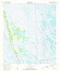
1957 Map of Mink Bayou
USGS Topo · Published 1963About this map
Bayou Lafourche anchors the western edge of this coastal landscape, serving as a primary corridor for settlement and industry amidst the marshes of Lafourche Parish. The 1950s era of energy exploration is clearly visible in the extensive Oil Field development near the bayou, marked by clusters of Oil Tanks and numerous Piling structures. This industrial activity contrasts with the intricate natural hydrology of the region, where waterways like Palmetto Bayou and Mink Bayou thread through a series of coastal bodies including Bay Rambo and Bay Jaque. In the south, the Southwestern Canal cuts through the terrain near South Lake and North Lake, illustrating the engineered modifications to the wetlands for navigation and drainage. A small Cem near the banks of the main bayou suggests the long-standing family settlements that have historically relied on these waters.
Find a feature on this map
24 named features on this map. Tap any name to fly to it.
Don’t see what you’re looking for? This feature index may not catch every label — zoom into the map to look around manually.
Map Details
Editions of this 1957 Mink Bayou Map
3 editions found
Other maps of this area

1892 · Cheniere Caminada
USGS Topo · 1:62,500

1892 · Creole
USGS Topo · 1:62,500

1894 · Timbalier
USGS Topo · 1:62,500

1894 · Lake Felicity
USGS Topo · 1:62,500

1935 · Bay Courant
USGS Topo · 1:31,680

1935 · Golden Meadow
USGS Topo · 1:31,680

1935 · Pelican Pass
USGS Topo · 1:31,680

1935 · Mink Bayou
USGS Topo · 1:31,680

1935 · Leeville
USGS Topo · 1:31,680

1939 · Lake Felicity
USGS Topo · 1:62,500