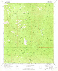
1969 Map of Minnehaha
USGS Topo · Published 1973About this map
Minnehaha sits within the high-elevation mining country of the Bradshaw Mountains and the Mc Allister Range, a landscape deeply marked by the quest for minerals during the late 1960s. This survey of the Prescott National Forest reveals a complex network of resource extraction and water management, including the Camp Bird Mine, Silver Dollar Mine, and the Chilean Mill. The presence of numerous developed springs such as Minnehaha Waters and Black Jack Spring, alongside cattle-related infrastructure like the ML Windmill, suggests a dual-use landscape where ranching coexisted with heavy prospecting. Remote outposts like Paxton Place and Indian Springs Camp are connected only by a rugged system of jeep trails and pack trails, illustrating the area's isolation from major thoroughfares. The terrain is characterized by massive features like Silver Mountain and the high Hooper Saddle, which defined the movements of miners and ranchers alike.
Find a feature on this map
85 named features on this map. Tap any name to fly to it.
Don’t see what you’re looking for? This feature index may not catch every label — zoom into the map to look around manually.
Map Details
Editions of this 1969 Minnehaha Map
Other maps of this area

1887 · Prescott
USGS Topo · 1:250,000

1892 · Prescott
USGS Topo · 1:250,000

1903 · Bradshaw Mountains
USGS Topo · 1:125,000

1903 · Congress
USGS Topo · 1:125,000

1904 · Congress
USGS Topo · 1:125,000

1947 · Crown King
USGS Topo · 1:62,500

1947 · Mt. Union
USGS Topo · 1:62,500

1947 · Kirkland
USGS Topo · 1:62,500

1947 · Wagoner
USGS Topo · 1:62,500

1948 · Crown King
USGS Topo · 1:63,360