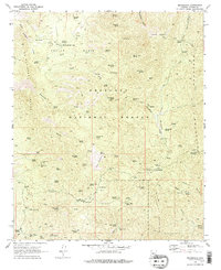
1969 Map of Minnehaha
USGS Topo · Published 1978About this map
Silver Mountain and the southern reaches of the Bradshaw Mountains define this rugged mining landscape within the Prescott National Forest. In the late 1960s, the area remained a hub of scattered mining activity and remote ranching infrastructure. Numerous workings like the Camp Bird Mine, Boaz Mine, and Button Mine are clustered near Minnehaha Creek, suggesting a history of hard-rock extraction.
Find a feature on this map
123 named features on this map. Tap any name to fly to it.
Don’t see what you’re looking for? This feature index may not catch every label — zoom into the map to look around manually.
Map Details
Editions of this 1969 Minnehaha Map
Other maps of this area

1887 · Prescott
USGS Topo · 1:250,000

1892 · Prescott
USGS Topo · 1:250,000

1903 · Bradshaw Mountains
USGS Topo · 1:125,000

1903 · Congress
USGS Topo · 1:125,000

1904 · Congress
USGS Topo · 1:125,000

1947 · Crown King
USGS Topo · 1:62,500

1947 · Mt. Union
USGS Topo · 1:62,500

1947 · Kirkland
USGS Topo · 1:62,500

1947 · Wagoner
USGS Topo · 1:62,500

1948 · Crown King
USGS Topo · 1:63,360