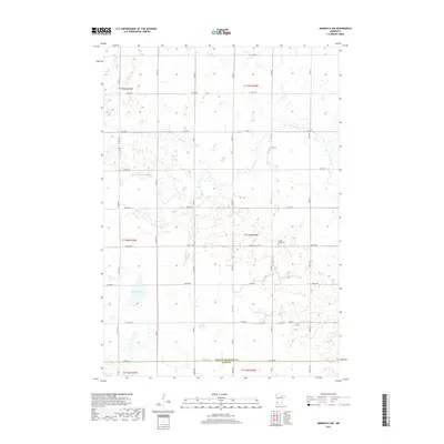
2019 Map of Minneota NW
USGS Topo · Published 2019About this map
The prairie landscape at the border of Yellow Medicine Co and Lyon Co is defined by a grid of agricultural section lines and small glacial depressions. In the southern portion of the quadrangle, Burton Lake sits as a prominent hydrologic feature among several smaller unnamed wetlands. Water management in this rural area is further evidenced by Spring Creek, which winds through the northern sections, passing south of the historic Israels Cemetery. Further south, Swede Home Cemetery serves as a significant landmark for genealogists and local historians, anchoring the community history of the surrounding townships. The map illustrates a sparse but meticulously organized network of county roads, such as County Highway 9 and County Highway 3, which facilitate the transport of agricultural goods across this corner of Southwest Minnesota.
Find a feature on this map
26 named features on this map. Tap any name to fly to it.
Don’t see what you’re looking for? This feature index may not catch every label — zoom into the map to look around manually.
Map Details
Editions of this 2019 Minneota NW Map
This is the sole edition of this map. No revisions or reprints were ever made.
Other maps of this area

1953 · Watertown
USGS Topo · 1:250,000

1953 · New Ulm
USGS Topo · 1:250,000

1957 · New Ulm
USGS Topo · 1:250,000

1958 · New Ulm
USGS Topo · 1:250,000

1958 · Watertown
USGS Topo · 1:250,000

1965 · Clarkfield
USGS Topo · 1:24,000

1965 · Boyd
USGS Topo · 1:24,000

1967 · New Ulm
USGS Topo · 1:250,000

1967 · Minneota
USGS Topo · 1:24,000
1967 · Green Valley
USGS Topo · 1:24,000