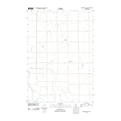
2010 Map of Minnesota Falls
USGS Topo · Published 2010About this map
Minnesota Falls provides a focused view of the agrarian landscape in Renville and Yellow Medicine counties at the start of the 2010s. The terrain is defined by the winding course of the Minnesota River in the southwest and the drainage patterns of Hawk Creek, Chetomba Creek, and Spring Creek. This rural section of Minnesota is characterized by a precise grid of township roads and county highways that segment the productive farmland. Cultural and genealogical markers are prominent across the countryside, including the Vestre Sogn Lutheran Cemetery, First Township Cemetery, and the Hawk Creek Lutheran Church Cemetery. These sites, along with the Johnson Airport in the east, illustrate the long-standing community hubs and transportation infrastructure that serve the region's agricultural economy.
Find a feature on this map
33 named features on this map. Tap any name to fly to it.
Don’t see what you’re looking for? This feature index may not catch every label — zoom into the map to look around manually.
Map Details
Editions of this 2010 Minnesota Falls Map
This is the sole edition of this map. No revisions or reprints were ever made.
Other maps of this area

1953 · New Ulm
USGS Topo · 1:250,000

1957 · New Ulm
USGS Topo · 1:250,000

1958 · New Ulm
USGS Topo · 1:250,000

1962 · Wood Lake
USGS Topo · 1:24,000

1965 · Lone Tree Lake
USGS Topo · 1:24,000

1965 · Asbury
USGS Topo · 1:24,000

1965 · Iverson Lake
USGS Topo · 1:24,000
1965 · Maynard
USGS Topo · 1:24,000
1965 · Clara City
USGS Topo · 1:24,000

1965 · Sacred Heart
USGS Topo · 1:24,000
Featured Places
- Granite Falls, MN
- Minnesota Falls, MN
- Renville County, MN
- Yellow Medicine County, MN
- Chippewa County, MN