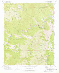
1972 Map of Miracle Hot Springs
USGS Topo · Published 1976About this map
The Kern River carves a deep path through the Sequoia National Forest in this 1970s topographic study, revealing a landscape defined by geothermal activity and early California mining operations. Resource extraction and outdoor recreation center on Miracle Hot Springs and Delonegha Hot Springs, while the Borel Canal and Borel Powerhouse reflect the early development of hydroelectric power in the region. Near the southern edge of the map, the historic settlement of Havilah serves as a focal point for researchers, flanked by the Havilah Forest Service Sta and evidence of a hard-rock mining legacy.
Find a feature on this map
64 named features on this map. Tap any name to fly to it.
Don’t see what you’re looking for? This feature index may not catch every label — zoom into the map to look around manually.
Map Details
Editions of this 1972 Miracle Hot Springs Map
3 editions found
Other maps of this area

1906 · Kernville
USGS Topo · 1:125,000

1908 · Kernville
USGS Topo · 1:125,000

1914 · Caliente
USGS Topo · 1:125,000

1915 · Mojave
USGS Topo · 1:125,000

1920 · Delonagha
USGS Topo · 1:62,500

1926 · Glennville
USGS Topo · 1:62,500

1936 · Tobias Peak
USGS Topo · 1:125,000

1943 · Emerald Mtn
USGS Topo · 1:62,500

1943 · Breckenridge Mountain
USGS Topo · 1:62,500

1943 · Tobias Peak
USGS Topo · 1:125,000