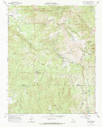
1966 Map of Miramonte
USGS Topo · Published 1967About this map
Miramonte and the surrounding high-altitude communities of the Sequoia National Forest are documented here during the mid-1960s, showing a landscape defined by forestry, conservation, and small mountain settlements. The map captures a transition from early industrial logging to active forest management, noting the Millwood (Site) alongside modern infrastructure like the McKenzie Heliport and the Miramonte Conservation Camp. Educational and spiritual life for these mountain residents is anchored by local landmarks including the Miramonte Sch, Sierra Sch, and Hilltop Chapel.
Find a feature on this map
57 named features on this map. Tap any name to fly to it.
Don’t see what you’re looking for? This feature index may not catch every label — zoom into the map to look around manually.
Map Details
Editions of this 1966 Miramonte Map
This is the sole edition of this map. No revisions or reprints were ever made.
Other maps of this area

1903 · Tehipite
USGS Topo · 1:125,000

1905 · Tehipite
USGS Topo · 1:125,000

1921 · Stokes Mountain
USGS Topo · 1:24,000

1922 · Trimmer
USGS Topo · 1:96,000

1924 · Dinuba
USGS Topo · 1:125,000

1924 · Stokes Mountain
USGS Topo · 1:31,680

1942 · Dunlap
USGS Topo · 1:62,500

1944 · Dunlap
USGS Topo · 1:62,500

1948 · Fresno
USGS Topo · 1:250,000

1952 · Tehipite Dome
USGS Topo · 1:62,500