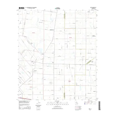
2015 Map of Mire
USGS Topo · Published 2015About this map
Mire and the surrounding prairie of southwestern Louisiana are defined by a complex network of bayous and coulees that dictate the placement of roads and homesteads. This landscape, situated at the intersection of Acadia, St. Landry, and Lafayette parishes, shows a persistent pattern of agricultural settlement along natural drainages like Bayou Wikoff and Coulee Duralde. Small rural clusters such as Higginbotham and Arceneaux anchor the local community, while Mount Calvary Cem serves as a significant genealogical landmark for area families. The map reveals the modern infrastructure of the 21st century, including the Stafford Airport near the eastern boundary and the expansion of residential roads like Albert Venable Rd and Roy Guidry Rd. These thoroughfares follow the historical township and range lines, creating a geometric grid that contrasts with the meandering paths of Bayou Queue De Tortue.
Find a feature on this map
73 named features on this map. Tap any name to fly to it.
Don’t see what you’re looking for? This feature index may not catch every label — zoom into the map to look around manually.
Map Details
Editions of this 2015 Mire Map
This is the sole edition of this map. No revisions or reprints were ever made.
Other maps of this area

1934 · Duson
USGS Topo · 1:31,680

1935 · Branch
USGS Topo · 1:31,680

1946 · Lafayette
USGS Topo · 1:31,680

1946 · Rayne
USGS Topo · 1:31,680

1947 · Branch
USGS Topo · 1:31,680

1947 · Pitreville
USGS Topo · 1:31,680

1952 · Lake Charles
USGS Topo · 1:250,000

1954 · Lafayette
USGS Topo · 1:31,680

1954 · Duson
USGS Topo · 1:31,680
1954 · Rayne
USGS Topo · 1:31,680