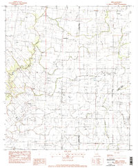
1983 Map of Mire
USGS Topo · Published 1983About this map
The agrarian and industrial landscape of Acadia Parish is defined here by the extensive development of energy resources interspersed with small prairie settlements in the early 1980s. Local commerce and community life center on small hubs like Mire, Bristol, and Higginbotham, while larger-scale land use is dominated by several major petroleum zones, including the Bosco Oil and Gas Field and the Church Point Oil and Gas Field. The map records a complex network of pipelines and unimproved roads connecting these fields across the low-lying drainage basins of Bayou Wikoff and Bayou Carencro. This 1983 edition highlights the rural-industrial character of the region, where family-named locales like Castille and Arceneaux exist alongside the heavy infrastructure of the South Bosco Oil and Gas Field, providing a precise record of Louisiana's Gulf Coast interior before late-century shifts in the oil industry.
Find a feature on this map
24 named features on this map. Tap any name to fly to it.
Don’t see what you’re looking for? This feature index may not catch every label — zoom into the map to look around manually.
Map Details
Editions of this 1983 Mire Map
This is the sole edition of this map. No revisions or reprints were ever made.
Other maps of this area

1934 · Duson
USGS Topo · 1:31,680

1935 · Branch
USGS Topo · 1:31,680

1946 · Lafayette
USGS Topo · 1:31,680

1946 · Rayne
USGS Topo · 1:31,680

1947 · Branch
USGS Topo · 1:31,680

1947 · Pitreville
USGS Topo · 1:31,680

1952 · Lake Charles
USGS Topo · 1:250,000

1954 · Lafayette
USGS Topo · 1:31,680

1954 · Duson
USGS Topo · 1:31,680
1954 · Rayne
USGS Topo · 1:31,680