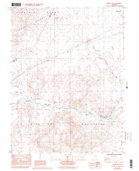
1985 Map of Misfits Flat
USGS Topo · Published 1993About this map
The California Emigrant Trail cuts a diagonal path across this Nevada landscape, tracing a historical corridor through the Carson Plains between the Virginia Range and the Pine Nut Mountains. This mid-1980s data illustrates a desert terrain defined by historical transit and water management, where the Carson River is flanked by vital irrigation works like the Upper Double Wood Pole Churchill Ditch and the Churchill and Houghman Ditch. These ditches reflect the enduring effort to divert water for agriculture and livestock in an otherwise arid basin.
Find a feature on this map
36 named features on this map. Tap any name to fly to it.
Don’t see what you’re looking for? This feature index may not catch every label — zoom into the map to look around manually.
Map Details
Editions of this 1985 Misfits Flat Map
3 editions found
Other maps of this area

1891 · Carson
USGS Topo · 1:125,000

1891 · Wabuska
USGS Topo · 1:125,000

1893 · Carson
USGS Topo · 1:125,000

1894 · Wabuska
USGS Topo · 1:125,000

1950 · Virginia City
USGS Topo · 1:62,500

1952 · Virginia City
USGS Topo · 1:62,500

1956 · Dayton
USGS Topo · 1:62,500

1957 · Como
USGS Topo · 1:62,500

1957 · Churchill Butte
USGS Topo · 1:62,500

1957 · Reno
USGS Topo · 1:250,000