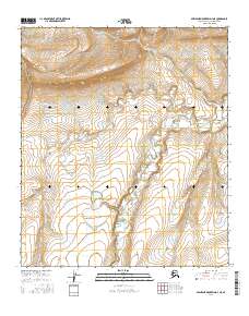
2016 Map of Misheguk Mountain D-3 NE
USGS Topo · Published 2016About this map
The Colville River flows across this remote stretch of the North Slope, appearing alongside the intermittent waters of Amo Cr. This 2016 survey highlights a landscape defined by expansive drainage patterns and significant elevation changes, where the high ground of the northern interior meets the headwaters of the Arctic slope. The map documents the vast, uninhabited terrain within the townships of t5s r36w, t5s r35w, t6s r36w, and t6s r35w, offering a clear view of the natural watercourses that have shaped this sub-arctic environment. For researchers and map collectors, the sheet provides a precise record of the topographic contours and hydrographic features of the Misheguk Mountain area before shifting environmental conditions further alter these northern waterways.
Find a feature on this map
6 named features on this map. Tap any name to fly to it.
Don’t see what you’re looking for? This feature index may not catch every label — zoom into the map to look around manually.
Map Details
Editions of this 2016 Misheguk Mountain D-3 NE Map
This is the sole edition of this map. No revisions or reprints were ever made.
Other maps of this area

1951 · Utukok River
USGS Topo · 1:250,000

1951 · Misheguk Mountain
USGS Topo · 1:250,000
1955 · Utukok River A-3
USGS Topo · 1:63,360

1956 · Misheguk Mountain
USGS Topo · 1:250,000

1956 · Utukok River
USGS Topo · 1:250,000

1965 · Utukok River
USGS Topo · 1:250,000
1984 · Misheguk Mountain D-3
USGS Topo · 1:63,360
1984 · Misheguk Mountain D-2
USGS Topo · 1:63,360
1984 · Utukok River A-2
USGS Topo · 1:63,360
2016 · Misheguk Mountain D-2 NW
USGS Topo · 1:25,000