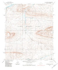
1984 Map of Utukok River A-2
USGS Topo · Published 1985About this map
National Petroleum Reserve in Alaska defines this section of the North Slope, where the drainage systems of two major Arctic waterways converge. In the north, the Utukok River meanders through the tundra, while the southern edge of the map follows the course of the Colville River. The landscape is dominated by the prominent east-west elevation of Lookout Ridge, which separates these watersheds. Between these rivers, the meandering Disappointment Creek carves a path through a series of named high points including Opine, Sap, Rain, and Sucker. This topographic study reveals a remote landscape characterized by its extreme northern hydrology and the survey lines that mark federal petroleum interests during the late twentieth century.
Find a feature on this map
15 named features on this map. Tap any name to fly to it.
Don’t see what you’re looking for? This feature index may not catch every label — zoom into the map to look around manually.
Map Details
Editions of this 1984 Utukok River A-2 Map
This is the sole edition of this map. No revisions or reprints were ever made.
Other maps of this area

1951 · Utukok River
USGS Topo · 1:250,000

1951 · Misheguk Mountain
USGS Topo · 1:250,000
1955 · Utukok River A-3
USGS Topo · 1:63,360
1955 · Utukok River B-3
USGS Topo · 1:63,360

1956 · Misheguk Mountain
USGS Topo · 1:250,000

1956 · Utukok River
USGS Topo · 1:250,000

1965 · Utukok River
USGS Topo · 1:250,000
1984 · Misheguk Mountain D-1
USGS Topo · 1:63,360
1984 · Misheguk Mountain D-3
USGS Topo · 1:63,360
1984 · Misheguk Mountain D-2
USGS Topo · 1:63,360