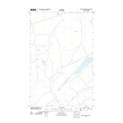
2011 Map of Mission Lake West
USGS Topo · Published 2011About this map
Upper Mission Lake and Mission Lake dominate the hydrography of this Glacier County landscape, reflecting the essential role of water storage and drainage in this part of Montana. The terrain is characterized by the broad Seville Flat and the meandering course of the Two Medicine River along the southern margin. This 2011 survey documents a network of local trails and tracks, including Augare Trl and Joe Show East Rd, which navigate the open country between established water sources like Damott Springs and Guardipee Lake. The presence of the Wasteway Coulee at the northern edge suggests the sophisticated irrigation and water management systems necessary for ranching and agriculture in this environment, providing a clear record of the area's modern land use and drainage patterns.
Find a feature on this map
11 named features on this map. Tap any name to fly to it.
Don’t see what you’re looking for? This feature index may not catch every label — zoom into the map to look around manually.
Map Details
Editions of this 2011 Mission Lake West Map
This is the sole edition of this map. No revisions or reprints were ever made.
Other maps of this area

1911 · Blackfoot
USGS Topo · 1:125,000

1914 · Heart Butte
USGS Topo · 1:125,000

1918 · Heart Butte
USGS Topo · 1:125,000

1960 · Cut Bank
USGS Topo · 1:250,000

1963 · Cut Bank
USGS Topo · 1:250,000

1964 · Cut Bank
USGS Topo · 1:250,000
1968 · Piegan
USGS Topo · 1:24,000

1968 · Rimrock Butte
USGS Topo · 1:24,000

1968 · White Man Coulee
USGS Topo · 1:24,000
1968 · Rocky Ridge
USGS Topo · 1:24,000