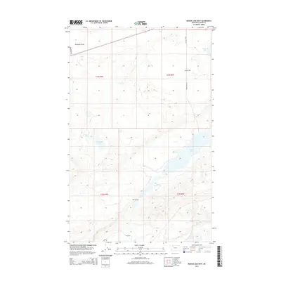
2014 Map of Mission Lake West
USGS Topo · Published 2014About this map
Mission Lake and its northern counterpart, Upper Mission Lake, anchor this high-plains landscape in Glacier County. The terrain is defined by dramatic depressions and drainage systems including Flat Coulee and Wasteway Coulee, which cut through the open expanses of Seville Flat. A network of local infrastructure such as Mission Lake Rd and the Augare Trl provides access across these expansive townships. To the west, Guardipee Lake and the nearby Lamott Springs offer additional water sources in a region characterized by its glacial geology. The southern edge of the quadrangle is marked by the winding course of the Two Medicine River, illustrating the fundamental hydrological patterns that have shaped the land's utility and settlement history in northern Montana.
Find a feature on this map
16 named features on this map. Tap any name to fly to it.
Don’t see what you’re looking for? This feature index may not catch every label — zoom into the map to look around manually.
Map Details
Editions of this 2014 Mission Lake West Map
This is the sole edition of this map. No revisions or reprints were ever made.
Other maps of this area

1911 · Blackfoot
USGS Topo · 1:125,000

1914 · Heart Butte
USGS Topo · 1:125,000

1918 · Heart Butte
USGS Topo · 1:125,000

1960 · Cut Bank
USGS Topo · 1:250,000

1963 · Cut Bank
USGS Topo · 1:250,000

1964 · Cut Bank
USGS Topo · 1:250,000
1968 · Piegan
USGS Topo · 1:24,000

1968 · Rimrock Butte
USGS Topo · 1:24,000

1968 · White Man Coulee
USGS Topo · 1:24,000
1968 · Rocky Ridge
USGS Topo · 1:24,000