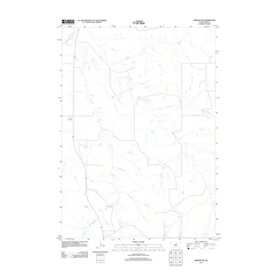
2012 Map of Mission NW
USGS Topo · Published 2012About this map
Little White River winds through the northwestern corner of this South Dakota landscape, part of a complex drainage network that defines the region's topography. The area is characterized by the branching paths of Horse Head Cr, Horse Cr, and W-Br Horse Cr, illustrating a geography shaped by these seasonal and perennial waterways. Along the western edge, U.S. Route 83 serves as the primary corridor for travel, passing near the Body of Christ Cem. This 2012 survey provides a clear view of the sparse rural development and significant water features that dominate the Antelope Segment of Todd County, reflecting the open character of the high plains before further modern expansion.
Find a feature on this map
6 named features on this map. Tap any name to fly to it.
Don’t see what you’re looking for? This feature index may not catch every label — zoom into the map to look around manually.
Map Details
Editions of this 2012 Mission NW Map
This is the sole edition of this map. No revisions or reprints were ever made.
Other maps of this area

1955 · Martin
USGS Topo · 1:250,000

1958 · Martin
USGS Topo · 1:250,000

1969 · Soldier Creek NE
USGS Topo · 1:24,000

1969 · Mission NW
USGS Topo · 1:24,000

1969 · Mission
USGS Topo · 1:24,000

1969 · Soldier Creek SE
USGS Topo · 1:24,000

1982 · Mission NE
USGS Topo · 1:24,000

1982 · White River SE
USGS Topo · 1:24,000

1982 · White River East
USGS Topo · 1:24,000
1982 · White River West
USGS Topo · 1:24,000
Featured Places
- Antelope Segment, SD
- Horse Creek Segment, SD
- Butte Creek Segment, SD
- Todd County, SD
- Mellette County, SD