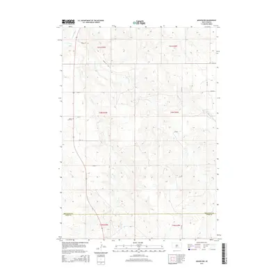
2015 Map of Mission NW
USGS Topo · Published 2015About this map
Little White River winds through the northwest corner of this South Dakota landscape, defining a terrain shaped by the intermittent drainage of Horse Cr and Horse Head Cr. This area of the Antelope Segment, situated on the border of Mellette and Todd Counties, reflects a rural pattern of township and range sections. Local history is anchored by the Body of Christ Cem, which sits along the established grid of section roads like 273rd St. The presence of named routes such as Broken Leg Rd suggests long-standing local landmarks in an area otherwise dominated by the natural drainage of the W Br Horse Cr. These geographical features provide a detailed view of the ranching and agricultural landscape in the mid-2010s.
Find a feature on this map
21 named features on this map. Tap any name to fly to it.
Don’t see what you’re looking for? This feature index may not catch every label — zoom into the map to look around manually.
Map Details
Editions of this 2015 Mission NW Map
This is the sole edition of this map. No revisions or reprints were ever made.
Other maps of this area

1955 · Martin
USGS Topo · 1:250,000

1958 · Martin
USGS Topo · 1:250,000

1969 · Soldier Creek NE
USGS Topo · 1:24,000

1969 · Mission NW
USGS Topo · 1:24,000

1969 · Mission
USGS Topo · 1:24,000

1969 · Soldier Creek SE
USGS Topo · 1:24,000

1982 · Mission NE
USGS Topo · 1:24,000

1982 · White River SE
USGS Topo · 1:24,000

1982 · White River East
USGS Topo · 1:24,000
1982 · White River West
USGS Topo · 1:24,000
Featured Places
- Antelope Segment, SD
- Horse Creek Segment, SD
- Butte Creek Segment, SD
- Todd County, SD
- Mellette County, SD