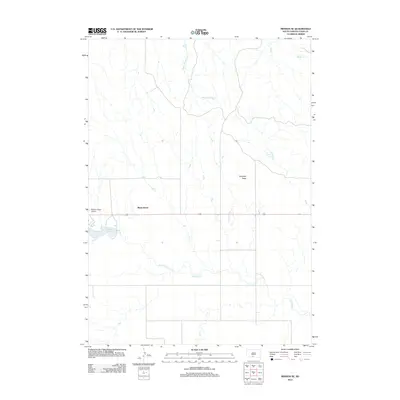
2012 Map of Mission SE
USGS Topo · Published 2012About this map
White Horse and the surrounding high plains of the Rosebud Indian Reservation are captured in this early 21st-century topographic study. The landscape is defined by the drainage networks of White Thunder Creek and Antelope Creek, which carve through the open terrain toward the north and east. The presence of the Mission Sioux Airport west of the central settlement area highlights the infrastructure serving this tribal land. Notable topographic landmarks like Haystack Butte rise above the drainage basins, providing distinct navigation points in an area otherwise characterized by vast stretches of prairie. Small water bodies including Antelope Lake and Tower Lake break the dry landscape, reflecting the essential role of water management in this part of Todd County.
Find a feature on this map
8 named features on this map. Tap any name to fly to it.
Don’t see what you’re looking for? This feature index may not catch every label — zoom into the map to look around manually.
Map Details
Editions of this 2012 Mission SE Map
This is the sole edition of this map. No revisions or reprints were ever made.
Other maps of this area

1955 · Martin
USGS Topo · 1:250,000

1958 · Martin
USGS Topo · 1:250,000

1969 · Mission NW
USGS Topo · 1:24,000

1969 · Mission
USGS Topo · 1:24,000

1969 · Olsonville NW
USGS Topo · 1:24,000

1982 · Mission NE
USGS Topo · 1:24,000

1982 · Olsonville
USGS Topo · 1:24,000

1982 · Hidden Timber
USGS Topo · 1:24,000

1982 · Okreek
USGS Topo · 1:25,000
1982 · Mission SE
USGS Topo · 1:24,000