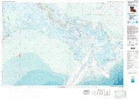
1983 Map of Mississippi River Delta
USGS Topo · Published 1983About this map
The Mississippi River winds through the heart of the lower delta, flanked by a narrow ribbon of development along La 23 that includes Port Sulphur, Buras, and Venice. This 1983 topographic-bathymetric study reveals the complex relationship between industrial utility and environmental conservation in the wetlands. The vast Sulphur Mining Area sits adjacent to sensitive coastal habitats like the Delta National Wildlife Refuge and the Bohemia State Wildlife Management Area.
Find a feature on this map
86 named features on this map. Tap any name to fly to it.
Don’t see what you’re looking for? This feature index may not catch every label — zoom into the map to look around manually.
Map Details
Editions of this 1983 Mississippi River Delta Map
2 editions found
Other maps of this area

1891 · Pointe a La Hache
USGS Topo · 1:62,500

1892 · Barataria
USGS Topo · 1:62,500

1892 · Cheniere Caminada
USGS Topo · 1:62,500

1892 · Quarantine
USGS Topo · 1:62,500

1892 · Creole
USGS Topo · 1:62,500

1892 · Pointe a La Hache
USGS Topo · 1:62,500

1893 · East Delta
USGS Topo · 1:62,500

1893 · La Fortuna
USGS Topo · 1:62,500

1893 · Forts
USGS Topo · 1:62,500

1893 · Fort Livingston
USGS Topo · 1:62,500