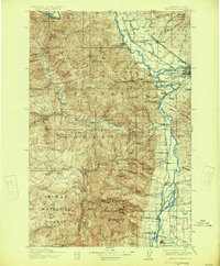
1912 Map of Missoula
USGS Topo · Published 1925About this map
Missoula serves as the focal point of this regional study, situated at the confluence of the Clark Fork and the Bitterroot River. The landscape is dominated by the sprawling boundaries of the Lolo National Forest and Bitterroot National Forest, where the terrain rises sharply to peaks like St Mary Pk and Diamond Pk. The mapping documents an era when river crossings were still managed by infrastructure like Alberts Ferry and Gilmans Ferry, and the timber industry was active at sites like the Old Sawmill. The Bitterroot Valley is punctuated by small rural schools such as Tuots School, Palm School, and Bass School, reflecting the scattered agricultural and ranching settlements like Gibbons Ranch and Ambrose that relied on the Bitterroot Branch and Northern Pacific railroads for connectivity.
Find a feature on this map
72 named features on this map. Tap any name to fly to it.
Don’t see what you’re looking for? This feature index may not catch every label — zoom into the map to look around manually.
Map Details
Editions of this 1912 Missoula Map
4 editions found
Other maps of this area

1901 · Hamilton
USGS Topo · 1:125,000

1903 · Bonner
USGS Topo · 1:125,000

1909 · Sapphire
USGS Topo · 1:125,000

1911 · Lolo
USGS Topo · 1:250,000

1912 · Missoula
USGS Topo · 1:125,000

1913 · Lolo
USGS Topo · 1:250,000

1921 · Elbow Lake
USGS Topo · 1:125,000

1947 · Butte
USGS Topo · 1:250,000

1955 · Choteau
USGS Topo · 1:250,000

1956 · Wallace
USGS Topo · 1:250,000