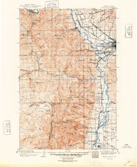
1912 Map of Missoula
USGS Topo · Published 1948About this map
The confluence of the Clark Fork and the Bitterroot River anchors this regional study, which shows the growth of Missoula and its outlying agricultural and industrial sites in the early twentieth century. To the west, the rugged Bitterroot Mountains rise sharply, punctuated by Lolo Pk and St Joseph Pk. The valley floor is crisscrossed by the competing lines of the Northern Pacific R R and the Chicago Milwaukee and Puget Sound R R, showing the rail-driven expansion that connected the Montana interior to the Pacific Northwest.
Find a feature on this map
89 named features on this map. Tap any name to fly to it.
Don’t see what you’re looking for? This feature index may not catch every label — zoom into the map to look around manually.
Map Details
Editions of this 1912 Missoula Map
4 editions found
Other maps of this area

1901 · Hamilton
USGS Topo · 1:125,000

1903 · Bonner
USGS Topo · 1:125,000

1909 · Sapphire
USGS Topo · 1:125,000

1911 · Lolo
USGS Topo · 1:250,000

1912 · Missoula
USGS Topo · 1:125,000

1913 · Lolo
USGS Topo · 1:250,000

1921 · Elbow Lake
USGS Topo · 1:125,000

1947 · Butte
USGS Topo · 1:250,000

1955 · Choteau
USGS Topo · 1:250,000

1956 · Wallace
USGS Topo · 1:250,000