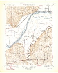
1947 Map of Missouri City
USGS Topo · Published 1947About this map
Missouri City sits at a strategic bend in the Missouri River on this mid-century survey, which reveals the landscape as it appeared before major suburban expansion. The river dominates the central corridor, carving through Jackson Bend and creating fertile bottomlands occupied by the Atherton settlement. To the north, the terrain rises sharply toward Nebo Hill, where rural schools like Nebo Sch and Lynch Sch served farming families. South of the river, the landscape transitions into the hills of Fort Osage, marked by a dense network of country roads and community anchors. Local historians can find numerous landmarks of early Jackson County, including Blue Mills and the McCune Home. The sheet preserves the location of several traditional country churches, such as New Salem Ch and Sixmile Ch, alongside an impressive number of rural schoolhouses like Elm Grove Sch and Hunt Sch.
Find a feature on this map
40 named features on this map. Tap any name to fly to it.
Don’t see what you’re looking for? This feature index may not catch every label — zoom into the map to look around manually.
Map Details
Editions of this 1947 Missouri City Map
2 editions found
Other maps of this area

1894 · Independence
USGS Topo · 1:125,000

1933 · Blue Springs
USGS Topo · 1:24,000

1934 · Oak Grove
USGS Topo · 1:24,000

1934 · Independence
USGS Topo · 1:24,000

1935 · Buckner
USGS Topo · 1:24,000

1935 · Missouri City
USGS Topo · 1:24,000

1935 · Liberty
USGS Topo · 1:24,000

1936 · Kearney
USGS Topo · 1:48,000

1940 · Liberty
USGS Topo · 1:31,680
1940 · Independence
USGS Topo · 1:31,680