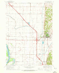
1970 Map of Missouri Valley
USGS Topo · Published 1972About this map
Missouri Valley stands as a significant rail and highway crossroads on the eastern edge of the Missouri River floodplain in the early 1970s. The town's grid is bounded by the winding course of Willow Creek, while the broader landscape is defined by the flat, fertile bottomlands of the Cincinnati and Taylor townships. To the northeast, the terrain shifts abruptly as the loess hills rise above the valley floor, providing a elevated location for Mt Carmel Cem. Water management is a primary feature of this agricultural corridor, evidenced by the channelized paths of Allen Creek and various drainage ditches that crisscross the low-lying plains west of the city. The infrastructure recorded here shows the intersection of local watercourses with the modern expansion of the regional transportation network during this period.
Find a feature on this map
4 named features on this map. Tap any name to fly to it.
Don’t see what you’re looking for? This feature index may not catch every label — zoom into the map to look around manually.
Map Details
Editions of this 1970 Missouri Valley Map
This is the sole edition of this map. No revisions or reprints were ever made.
Other maps of this area

1893 · Omaha
USGS Topo · 1:62,500

1893 · Fremont
USGS Topo · 1:125,000

1896 · Fremont
USGS Topo · 1:125,000

1954 · Omaha
USGS Topo · 1:250,000

1955 · Fremont
USGS Topo · 1:250,000

1957 · Fremont
USGS Topo · 1:250,000

1957 · Omaha
USGS Topo · 1:250,000

1957 · Loveland
USGS Topo · 1:24,000

1957 · Honey Creek
USGS Topo · 1:24,000

1958 · Omaha
USGS Topo · 1:250,000