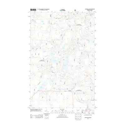
2013 Map of Mitawan Lake
USGS Topo · Published 2013About this map
Superior National Forest encompasses this section of Lake County, where a dense network of glacial lakes and tributaries defines the northern wilderness. The Little Isabella River meanders across the southern portion of the map, serving as a focal point for recreation at the Little Isabella River Campground. The presence of several named water bodies, such as Mitawan Lake, Steamhaul Lake, and Flat Horn Lake, suggests a landscape shaped by historical logging and modern conservation. Surface travel is supported by State Hwy 1 and numerous forest routes, including Tomahawk Rd and Forest Rte 949. Near Lake Gegoka, the Lake Gegoka Ski Trl indicates a transition toward managed recreational use within this protected woodland environment.
Find a feature on this map
39 named features on this map. Tap any name to fly to it.
Don’t see what you’re looking for? This feature index may not catch every label — zoom into the map to look around manually.
Map Details
Editions of this 2013 Mitawan Lake Map
This is the sole edition of this map. No revisions or reprints were ever made.
Other maps of this area

1954 · Greenwood Lake
USGS Topo · 1:62,500

1954 · Two Harbors
USGS Topo · 1:250,000

1955 · Isabella
USGS Topo · 1:62,500

1957 · Two Harbors
USGS Topo · 1:250,000

1957 · Gabbro Lake
USGS Topo · 1:62,500

1958 · Two Harbors
USGS Topo · 1:250,000

1964 · Two Harbors
USGS Topo · 1:250,000
1981 · Gabbro Lake
USGS Topo · 1:24,000
1981 · Isabella
USGS Topo · 1:24,000
1981 · Slate Lake East
USGS Topo · 1:24,000