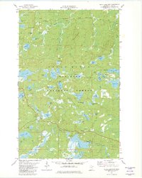
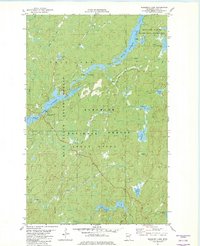
1981 Map of Slate Lake East
USGS Topo · Published 1982About this map
The Superior National Forest in Lake County defines this wilderness landscape, where the Isabella River and Snake River wind through dense northern woods. This 1981 survey documents a network of glacial lakes and waterways, ranging from the prominent Slate Lake to smaller basins like Dragon Lake, Beetle Lake, and Swallow Lake. Human presence is minimal and largely centered on seasonal access, marked by the Tomahawk Road corridors and a Winter Trail. Notable landmarks for researchers and outdoorsmen include the established Camp Buckskin and Camp E, alongside multiple boat ramps providing access to the interior. The map illustrates a complex hydraulic environment characterized by peat-rich waters such as Sphagnum Cr and significant elevations like Jack Pine Mountain, providing a clear view of the region's topography before more modern developmental shifts in the North Woods.
Find a feature on this map
57 named features on this map. Tap any name to fly to it.
Don’t see what you’re looking for? This feature index may not catch every label — zoom into the map to look around manually.
Map Details
Editions of this 1981 Slate Lake East Map
2 editions found
Other maps of this area

1954 · Greenwood Lake
USGS Topo · 1:62,500

1954 · Two Harbors
USGS Topo · 1:250,000

1955 · Isabella
USGS Topo · 1:62,500

1957 · Two Harbors
USGS Topo · 1:250,000

1957 · Gabbro Lake
USGS Topo · 1:62,500

1958 · Two Harbors
USGS Topo · 1:250,000

1964 · Two Harbors
USGS Topo · 1:250,000
1981 · Gabbro Lake
USGS Topo · 1:24,000
1981 · Slate Lake West
USGS Topo · 1:24,000
1981 · Bogberry Lake
USGS Topo · 1:24,000