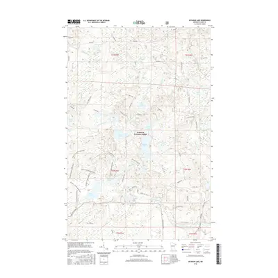
2016 Map of Mitawan Lake
USGS Topo · Published 2016About this map
Superior National Forest encompasses this aquatic landscape in the mid-2010s, defined by a dense network of glacial lakes and the winding Little Isabella River. The area serves as a significant drainage basin where Mitawan Creek and Sphagnum Creek link smaller bodies like Mitawan Lake and Lake Gegoka. Transportation in this part of Lake County is primarily oriented toward resource management and recreation, evidenced by an extensive system of named forest roads including the Tomahawk and numerous spurs. The presence of the DMIR Grade in the southeastern corner points to the region's industrial heritage, specifically the infrastructure once required for timber or ore transport. From the secluded waters of Steamhaul Lake to the aptly named Fishfry Lake, the map documents a territory where the natural hydrography dictates the placement of every connector road and trail.
Find a feature on this map
54 named features on this map. Tap any name to fly to it.
Don’t see what you’re looking for? This feature index may not catch every label — zoom into the map to look around manually.
Map Details
Editions of this 2016 Mitawan Lake Map
This is the sole edition of this map. No revisions or reprints were ever made.
Other maps of this area

1954 · Greenwood Lake
USGS Topo · 1:62,500

1954 · Two Harbors
USGS Topo · 1:250,000

1955 · Isabella
USGS Topo · 1:62,500

1957 · Two Harbors
USGS Topo · 1:250,000

1957 · Gabbro Lake
USGS Topo · 1:62,500

1958 · Two Harbors
USGS Topo · 1:250,000

1964 · Two Harbors
USGS Topo · 1:250,000
1981 · Gabbro Lake
USGS Topo · 1:24,000
1981 · Isabella
USGS Topo · 1:24,000
1981 · Slate Lake East
USGS Topo · 1:24,000