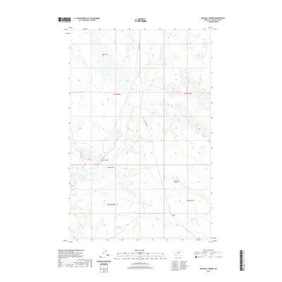
2020 Map of Mitchell Corner
USGS Topo · Published 2020About this map
Alkali Flat dominates the northern landscape of this Phillips County region, where the drainage patterns of the northern Missouri River breaks begin to take shape. The map illustrates a sparse, ranching-oriented topography defined by intricate coulees and seasonal waterways. Mitchell Corner serves as the primary named landmark in the southern portion of the quadrangle, situated near the head of Seven Mile Coulee. Local water management is evident at the Puckett Reservoir, a critical feature in this arid environment. The path of Beaver Cr and its tributaries like Little Sevenmile Cr carve through the terrain, flanked by notable landforms such as Nelson Coulee and Camp Coulee. Access through this remote Montana stretch is maintained primarily via Sun Prairie Rd, which bisects several township boundaries including t27n r30e and t26n r31e.
Find a feature on this map
13 named features on this map. Tap any name to fly to it.
Don’t see what you’re looking for? This feature index may not catch every label — zoom into the map to look around manually.
Map Details
Editions of this 2020 Mitchell Corner Map
This is the sole edition of this map. No revisions or reprints were ever made.
Other maps of this area

1954 · Jordan
USGS Topo · 1:250,000

1954 · Glasgow
USGS Topo · 1:250,000

1956 · Jordan
USGS Topo · 1:250,000

1957 · Glasgow
USGS Topo · 1:250,000

1958 · Glasgow
USGS Topo · 1:250,000

1958 · Jordan
USGS Topo · 1:250,000

1964 · Jordan
USGS Topo · 1:250,000

1965 · Whitcomb Lake
USGS Topo · 1:24,000

1965 · Sheep Coulee
USGS Topo · 1:24,000
1965 · Emond Ranch
USGS Topo · 1:24,000