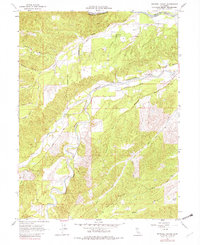
1965 Map of Mitchell Gulch
USGS Topo · Published 1982About this map
Evergreen Sch, Bowman Sch, and Farquhar Sch are prominent landmarks in this rural landscape, which sits along the winding boundary between Shasta and Tehama Counties. The convergence of Cottonwood Creek and its South Fork serves as a geographic anchor, while a network of rural routes like Evergreen Road and Bowman Road connects small-scale farming and ranching operations. The terrain is deeply incised by a series of drainages including Mitchell Gulch, Devils Gulch, and China Gulch, which dictate the placement of local homesteads and jeep trails. The presence of the Baker Fire Control Station underscores the managed nature of this landscape during the mid-1960s, reflecting a period when localized infrastructure was vital for community safety and land stewardship in northern California.
Find a feature on this map
25 named features on this map. Tap any name to fly to it.
Don’t see what you’re looking for? This feature index may not catch every label — zoom into the map to look around manually.
Map Details
Editions of this 1965 Mitchell Gulch Map
3 editions found
Other maps of this area

1890 · Red Bluff
USGS Topo · 1:250,000

1894 · Red Bluff
USGS Topo · 1:250,000

1932 · Olinda
USGS Topo · 1:31,680

1935 · Olinda
USGS Topo · 1:31,680

1947 · Anderson
USGS Topo · 1:62,500

1948 · Anderson
USGS Topo · 1:62,500

1949 · Colyear Springs
USGS Topo · 1:62,500

1951 · Red Bluff West
USGS Topo · 1:24,000

1952 · Blossom
USGS Topo · 1:24,000

1952 · Ono
USGS Topo · 1:62,500