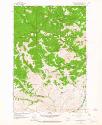
1962 Map of Mitchell Mountain
USGS Topo · Published 1964About this map
Mitchell Mountain dominates the western half of this landscape, its steep slopes giving way to a network of drainage forks and gulches that defined the early ranching and transport routes of Lewis and Clark County. In the southeast corner, the small settlement of Sieben sits at the nexus of the Great Northern rail line and a series of rural arteries including the Sieben Ranch Road and Wirth Sieben Road. The drainage patterns, including the convergence of Big Sheep Creek and Little Sheep Creek, suggest a terrain shaped by livestock grazing and seasonal water management, reinforced by the presence of a Ditch and a Pipeline cutting through the lower elevations. The map also traces the winding courses of North Fork Lyons Creek and Medicine Rock Creek, providing a detailed look at the geographic character of the region as it transitioned from traditional ranching toward modern infrastructure in the early 1960s.
Find a feature on this map
21 named features on this map. Tap any name to fly to it.
Don’t see what you’re looking for? This feature index may not catch every label — zoom into the map to look around manually.
Map Details
Editions of this 1962 Mitchell Mountain Map
2 editions found
Other maps of this area

1889 · Helena
USGS Topo · 1:250,000

1893 · Helena
USGS Topo · 1:250,000

1899 · Helena
USGS Topo · 1:250,000

1903 · Helena
USGS Topo · 1:250,000

1943 · Hogan
USGS Topo · 1:125,000

1947 · Butte
USGS Topo · 1:250,000

1955 · Choteau
USGS Topo · 1:250,000

1957 · Choteau
USGS Topo · 1:250,000

1958 · Butte
USGS Topo · 1:250,000

1958 · Choteau
USGS Topo · 1:250,000