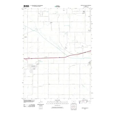
2010 Map of Mitchellville
USGS Topo · Published 2010About this map
The South Skunk River meanders across this Central Iowa landscape, defining the topography between the town of Mitchellville and the smaller settlements of Valeria and Oswalt. In this 2010 survey, the land remains dominated by a systematic grid of section roads, including Hwy F34 W and Federal Ave, which connect long-standing rural communities. Genealogists will find a significant concentration of burial sites throughout the quadrangle, such as the Greencastle Cemetery near the community of Green Castle and the McKeever Cemetery to the east. The map captures the interface of established townships with water features like Santiago Creek and Clarks Lake, illustrating the persistent agricultural and residential patterns of the region. From the Mitchellville Post Office to the edge of Colfax, the sheet provides a clear view of the area's developed infrastructure just north of the Squaw Creek drainage.
Find a feature on this map
63 named features on this map. Tap any name to fly to it.
Don’t see what you’re looking for? This feature index may not catch every label — zoom into the map to look around manually.
Map Details
Editions of this 2010 Mitchellville Map
This is the sole edition of this map. No revisions or reprints were ever made.
Other maps of this area

1930 · Mitchellville
USGS Topo · 1:62,500

1954 · Des Moines
USGS Topo · 1:250,000

1956 · Des Moines
USGS Topo · 1:250,000

1957 · Des Moines
USGS Topo · 1:250,000

1965 · Prairie City
USGS Topo · 1:24,000

1965 · Colfax
USGS Topo · 1:24,000

1969 · Des Moines
USGS Topo · 1:250,000
1972 · Runnells
USGS Topo · 1:24,000
1972 · Altoona
USGS Topo · 1:24,000
1972 · Rising Sun
USGS Topo · 1:24,000