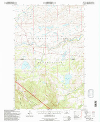
1995 Map of Mitten Lake
USGS Topo · Published 1997About this map
The Blackfeet Indian Reservation meets the northern boundary of the Lewis and Clark National Forest in this mid-1990s survey of the Montana high country. The landscape is defined by the transition from the rolling plains of the reservation into the steep ascent of Lookout Ridge. Significant water bodies like Mitten Lake and Horn Lake sit tucked within the topographical folds of the terrain, while the drainage systems of Badger Creek and Whitetail Creek carve through the foothills. A notable human landmark is the Swims Under Sch, located near the creek banks where the reservation land meets the county line. This map provides a detailed view of tribal and federal land management boundaries during the late 20th century, showing the established National Forest Boundary as it skirts the peaks and glacial lakes of the Rocky Mountain Front.
Find a feature on this map
17 named features on this map. Tap any name to fly to it.
Don’t see what you’re looking for? This feature index may not catch every label — zoom into the map to look around manually.
Map Details
Editions of this 1995 Mitten Lake Map
This is the sole edition of this map. No revisions or reprints were ever made.
Other maps of this area

1913 · Marias Pass
USGS Topo · 1:125,000

1914 · Heart Butte
USGS Topo · 1:125,000

1918 · Heart Butte
USGS Topo · 1:125,000

1960 · Cut Bank
USGS Topo · 1:250,000

1963 · Cut Bank
USGS Topo · 1:250,000

1964 · Cut Bank
USGS Topo · 1:250,000

1968 · Half Dome Crag
USGS Topo · 1:24,000

1968 · Swift Reservoir
USGS Topo · 1:24,000

1968 · Fish Lake
USGS Topo · 1:24,000

1968 · White Man Coulee
USGS Topo · 1:24,000