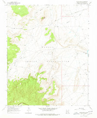
1966 Map of Mitten Rock
USGS Topo · Published 1978About this map
Navajo Indian Reservation lands dominate this mid-century landscape, centered on the prominent monolith of Mitten Rock. The terrain is defined by a series of drainage systems including Salt Wash, Little Shiprock Wash, and the extensive Shiprock Wash, which carve through the high desert floor toward the northern reaches of Beautiful Mountain. Water management is a critical visible element of this arid environment, evidenced by scattered Flowing Wells, a Flowing Well, and the Big Gap Reservoir nestled near the base of Rock Ridge. The Red Rock Highway provides the primary transit artery across the northern portion of the map, while a network of unimproved trails and a significant Pipeline corridor suggest the infrastructure supporting the local ranching and resource economy during the 1960s. This survey offers a precise record of hydrologic and geologic features in San Juan County before more modern developments.
Find a feature on this map
19 named features on this map. Tap any name to fly to it.
Don’t see what you’re looking for? This feature index may not catch every label — zoom into the map to look around manually.
Map Details
Editions of this 1966 Mitten Rock Map
3 editions found
Other maps of this area

1889 · Chaco
USGS Topo · 1:250,000

1892 · Chaco
USGS Topo · 1:250,000

1892 · Canyon De Chelly
USGS Topo · 1:250,000

1934 · Ship Rock
USGS Topo · 1:62,500

1937 · Ship Rock
USGS Topo · 1:62,500

1953 · Sanostee
USGS Topo · 1:62,500

1953 · Redrock Valley NE
USGS Topo · 1:24,000

1953 · Redrock Valley SE
USGS Topo · 1:24,000

1953 · Redrock Valley
USGS Topo · 1:62,500

1954 · Shiprock
USGS Topo · 1:250,000