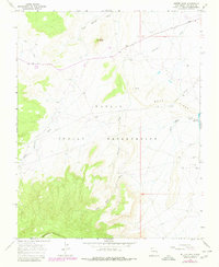
1966 Map of Mitten Rock
USGS Topo · Published 1980About this map
Navajo Indian Reservation lands in San Juan County define this landscape, where the high desert meets the northern slopes of Beautiful Mountain. The survey captures a mid-century infrastructure in transition, documenting the Red Rock Highway and an extensive Pipeline network that cuts across the arid terrain. Natural drainage patterns are clearly delineated by the paths of Little Shiprock Wash, Salt Wash, and Dead Mans Wash, while the namesake Mitten Rock rises as a prominent landmark in the north-central sector.
Find a feature on this map
16 named features on this map. Tap any name to fly to it.
Don’t see what you’re looking for? This feature index may not catch every label — zoom into the map to look around manually.
Map Details
Editions of this 1966 Mitten Rock Map
3 editions found
Other maps of this area

1889 · Chaco
USGS Topo · 1:250,000

1892 · Chaco
USGS Topo · 1:250,000

1892 · Canyon De Chelly
USGS Topo · 1:250,000

1934 · Ship Rock
USGS Topo · 1:62,500

1937 · Ship Rock
USGS Topo · 1:62,500

1953 · Sanostee
USGS Topo · 1:62,500

1953 · Redrock Valley NE
USGS Topo · 1:24,000

1953 · Redrock Valley SE
USGS Topo · 1:24,000

1953 · Redrock Valley
USGS Topo · 1:62,500

1954 · Shiprock
USGS Topo · 1:250,000