
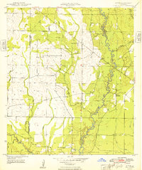
1935 Map of Mittie
USGS Topo · Published 1935About this map
Mittie sits at the heart of this 1935 survey, a landscape defined by the transition from timber extraction to permanent settlement. The presence of an Old Logging Railroad Grade and active Logging Railroad lines indicates the industrial heritage of this portion of Allen Parish, where timber was once the primary economic driver. These transit lines cut across a complex network of waterways, most notably the meandering Whisky Chitto Creek and Bundick Creek. Locally significant landmarks like the Cherry Grove Ch and the Simmons Settlement suggest the social centers of this rural community during the mid-1930s. The map also documents the early state road system, featuring State Highway No 190 and State Highway No 52, which began to modernize travel through the piney woods and bottomlands along Tenmile Creek and Flat Creek.
Find a feature on this map
19 named features on this map. Tap any name to fly to it.
Don’t see what you’re looking for? This feature index may not catch every label — zoom into the map to look around manually.
Map Details
Editions of this 1935 Mittie Map
This is the sole edition of this map. No revisions or reprints were ever made.
Other maps of this area

1947 · Oberlin
USGS Topo · 1:31,680

1947 · Pine Chapel
USGS Topo · 1:31,680

1947 · Le Blanc
USGS Topo · 1:31,680

1947 · Reeves
USGS Topo · 1:31,680

1947 · Elizabeth
USGS Topo · 1:31,680

1947 · Grant
USGS Topo · 1:31,680

1947 · Bundick
USGS Topo · 1:31,680

1947 · Sugartown
USGS Topo · 1:31,680

1948 · Grant
USGS Topo · 1:24,000
1948 · Mittie
USGS Topo · 1:24,000