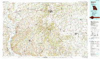
1985 Map of Moberly
USGS Topo · Published 1990About this map
Moberly serves as the primary urban hub on this mid-1980s landscape, situated at a critical junction where the Norfolk and Western Railway intersects with major regional highways. The terrain transition between the river bottoms and the upland prairie is marked by the presence of strip mines and substantial water features like the Sterling Price Community Lake and Larrabee Lake. This edition captures a mix of established municipal infrastructure, such as the Omar N Bradley Airport, and significant conservation and recreation lands including the Rudolf Bennitt State Wildlife Area and Finger Lakes State Park. Along the Missouri River, landmarks like Arrow Rock State Park and Boons Lick highlight the area's deep historical roots, while smaller settlements like Fayette, Centralia, and Salisbury are shown with their full street grids and local landmarks like Sunset Hill Cem.
Find a feature on this map
83 named features on this map. Tap any name to fly to it.
Don’t see what you’re looking for? This feature index may not catch every label — zoom into the map to look around manually.
Map Details
Editions of this 1985 Moberly Map
2 editions found
Other maps of this area

1886 · Jefferson City
USGS Topo · 1:125,000

1887 · Sedalia
USGS Topo · 1:125,000

1888 · Boonville
USGS Topo · 1:125,000

1890 · Mexico
USGS Topo · 1:125,000

1890 · Moberly
USGS Topo · 1:125,000

1890 · Glasgow
USGS Topo · 1:125,000

1890 · Fulton
USGS Topo · 1:125,000

1890 · Marshall
USGS Topo · 1:125,000

1892 · Marshall
USGS Topo · 1:125,000

1894 · Sedalia
USGS Topo · 1:125,000