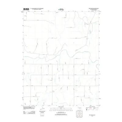
2012 Map of Mocane SW
USGS Topo · Published 2012About this map
The Beaver River winds through the northern Panhandle landscape, defining the topography of this corner of Beaver County. In this section of the High Plains, the river’s path is flanked by a series of significant tributaries, including Clear Cr and Cottonwood Cr, which carve through the terrain to join the main channel. The map reveals a strictly organized section-line road network typical of the region's agricultural layout, with routes like e0150 RD and n1430 RD providing access across the vast open spaces. Small drainages such as Spring Cr and Timber Cr indicate the subtle shifts in elevation and the importance of water management in this semi-arid environment, where natural creek beds often dictate the placement of ranching infrastructure and local landmarks.
Find a feature on this map
54 named features on this map. Tap any name to fly to it.
Don’t see what you’re looking for? This feature index may not catch every label — zoom into the map to look around manually.
Map Details
Editions of this 2012 Mocane SW Map
This is the sole edition of this map. No revisions or reprints were ever made.
Other maps of this area

1954 · Perryton
USGS Topo · 1:250,000

1958 · Perryton
USGS Topo · 1:250,000

1970 · Mocane NW
USGS Topo · 1:24,000

1970 · Mocane SE
USGS Topo · 1:24,000
1970 · Mocane
USGS Topo · 1:24,000

1971 · Clear Lake NW
USGS Topo · 1:24,000

1971 · Clear Lake
USGS Topo · 1:24,000
1971 · Mocane SW
USGS Topo · 1:24,000

1973 · Balko NE
USGS Topo · 1:24,000
1973 · Forgan
USGS Topo · 1:24,000