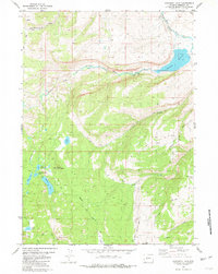
1981 Map of Moccasin Lake
USGS Topo · Published 1981About this map
Washakie Reservoir and the winding course of the South Fork Little Wind River define this high-elevation landscape within the Wind River Indian Reservation. The 1981 survey reveals a complex network of glacial lakes and dramatic peaks, where the transition from river valleys to alpine heights is marked by the presence of Mount Popo Agie and Mount Cross. The map illustrates a reliance on primitive transportation routes, showing numerous pathways like the Moccasin Lake Road and a dense system of trails, including several designated as Pack Trail and Jeep Trail, which provide access to remote water bodies such as Pie Lake and Moccasin Lake. This terrain, characterized by steep drainages like Trout Creek and Cottonwood Creek, remains largely unsettled, serving primarily as a corridor for water management and wilderness travel.
Find a feature on this map
28 named features on this map. Tap any name to fly to it.
Don’t see what you’re looking for? This feature index may not catch every label — zoom into the map to look around manually.
Map Details
Editions of this 1981 Moccasin Lake Map
3 editions found
Other maps of this area

1937 · Moccasin Lake
USGS Topo · 1:48,000

1943 · Moccasin Lake
USGS Topo · 1:62,500

1951 · Fort Washakie
USGS Topo · 1:24,000

1952 · Wise Flat
USGS Topo · 1:24,000

1952 · Wind River
USGS Topo · 1:24,000

1952 · St. Lawrence Basin
USGS Topo · 1:24,000

1953 · Mount Arter
USGS Topo · 1:24,000

1955 · Thermopolis
USGS Topo · 1:250,000

1955 · Lander
USGS Topo · 1:250,000

1958 · Lander
USGS Topo · 1:250,000