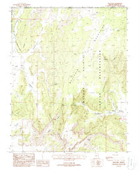
1988 Map of Moccasin
USGS Topo · Published 1988About this map
Moccasin and the surrounding Kaibab Indian Reservation define this high-desert landscape in northern Arizona. The settlement is centered around vital water sources including Moccasin Spring, Upper Moccasin Springs, and Meeks Spring, which supported the early community and livestock in this arid region. The map reveals the local infrastructure of the late 1980s, noting the Rodeo Ground and a local Cem just south of the main town site. Dramatic geological features dominate the horizon, from the towering Vermilion Cliffs and Moccasin Mountains to named points like Lone Butte and Cedar Ridge. These natural barriers are cut by deep passages such as Woodberry Canyon and Potter Canyon, illustrating the challenging terrain that shaped western settlement and movement between the plateaus.
Find a feature on this map
30 named features on this map. Tap any name to fly to it.
Don’t see what you’re looking for? This feature index may not catch every label — zoom into the map to look around manually.
Map Details
Editions of this 1988 Moccasin Map
This is the sole edition of this map. No revisions or reprints were ever made.
Other maps of this area

1886 · Kanab
USGS Topo · 1:250,000

1886 · Kaibab
USGS Topo · 1:250,000

1953 · Cedar City
USGS Topo · 1:250,000

1953 · Grand Canyon
USGS Topo · 1:250,000

1954 · Kanab SW
USGS Topo · 1:24,000
1954 · Short Creek SW
USGS Topo · 1:24,000

1954 · Fredonia NW
USGS Topo · 1:24,000

1954 · Short Creek SE
USGS Topo · 1:24,000
1954 · Short Creek NW
USGS Topo · 1:24,000

1954 · Fredonia SW
USGS Topo · 1:24,000