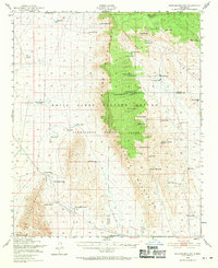
1948 Map of Mockingbird Gap
USGS Topo · Published 1971About this map
The Oscura Mountains dominate the center of this landscape, serving as a backdrop for the military expansion of the mid-twentieth century. Based on 1948 field checks, the map captures a transition as traditional ranching outposts like A D Helm Ranch and Withers Ranch sit alongside the White Sands Proving Ground and the Alamogordo Bombing Range. The strategic shift is evident in markers such as the Demolition Target and the Air Strip (Abandoned), while the McDonald Ranch (Abandoned) signals the displacement of earlier homesteads. Water remains the critical factor for survival in this arid terrain, documented through numerous family-named sources like Kidd & Duffy Spring and Palomas Moonshine Spring. At the southern edge of the mountains, Mockingbird Gap provides a natural pass through the high ground, while the small settlement of Estes City is positioned near the eastern foothills.
Find a feature on this map
50 named features on this map. Tap any name to fly to it.
Don’t see what you’re looking for? This feature index may not catch every label — zoom into the map to look around manually.
Map Details
Editions of this 1948 Mockingbird Gap Map
2 editions found

Other maps of this area

1916 · Salinas Peak
USGS Topo · 1:125,000

1916 · Tularosa
USGS Topo · 1:125,000

1918 · Oscura Peak
USGS Topo · 1:125,000

1947 · Three Rivers
USGS Topo · 1:62,500

1947 · Capitol Peak
USGS Topo · 1:62,500

1948 · Carthage
USGS Topo · 1:62,500

1948 · Broken Back Crater
USGS Topo · 1:62,500

1948 · Granjean Well
USGS Topo · 1:62,500

1948 · Bingham
USGS Topo · 1:62,500

1948 · Chihuahua Ranch
USGS Topo · 1:62,500