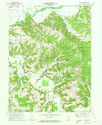
1970 Map of Modesto
USGS Topo · Published 1972About this map
Morgan-Monroe State Forest dominates the high ground in this 1970 survey, preserving a large swath of timberland across the Morgan Co Monroe Co line. The northern border of the map is defined by the White River and the tracks of the Penn Central railroad, which serve as the primary transit corridor near the Paragon Bridge. Below the forest ridges, the landscape transitions into the drainage basins of Beanblossom Creek and Indian Creek, where rural life is anchored by a dense network of country churches and family burial grounds. Notable local institutions include the New Salem Ch, Zion Hill Ch, and the Brown Sch, while the community of Modesto sits at a crossroads in the southern section. The intricate terrain of hollows, such as Bear Hollow and Fox Hollow, reveals the complex topography that dictated the placement of early homesteads and winding roads like Union Road.
Find a feature on this map
52 named features on this map. Tap any name to fly to it.
Don’t see what you’re looking for? This feature index may not catch every label — zoom into the map to look around manually.
Map Details
Editions of this 1970 Modesto Map
3 editions found
Other maps of this area

1908 · Bloomington
USGS Topo · 1:48,000

1910 · Bloomington
USGS Topo · 1:62,500

1942 · Franklin
USGS Topo · 1:125,000

1947 · Unionville
USGS Topo · 1:24,000

1947 · Gosport
USGS Topo · 1:24,000

1948 · Hindustan
USGS Topo · 1:24,000

1949 · Quincy
USGS Topo · 1:24,000

1950 · Gosport
USGS Topo · 1:24,000

1953 · Indianapolis
USGS Topo · 1:250,000

1955 · Martinsville
USGS Topo · 1:24,000