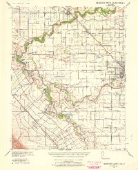
1941 Map of Modesto West
USGS Topo · Published 1960About this map
The San Joaquin River and Tuolumne River dominate this Central Valley landscape, defining the agricultural and transport patterns of the early 1940s. Irrigation is a central feature of the terrain, visible through a complex network of channels including the Main Canal and numerous numbered laterals like Lateral No 4. The map captures a period of significant social transition, marked by the presence of the Farm Security Administration Camp near Westley. Smaller, potentially vanished settlements and rural schoolhouses such as Shiloh School, Laird School, and Ransom School are scattered across the valley floor, alongside the historic boundaries of Rancho Del Puerto. Rail infrastructure is well-represented by the Southern Pacific Railroad and the San Francisco and New Orleans Line, highlighting the area's role as a major transportation corridor between Modesto and the surrounding farming communities of Grayson and Salida.
Find a feature on this map
62 named features on this map. Tap any name to fly to it.
Don’t see what you’re looking for? This feature index may not catch every label — zoom into the map to look around manually.
Map Details
Editions of this 1941 Modesto West Map
3 editions found
Other maps of this area

1913 · Romain
USGS Topo · 1:31,680

1914 · Manteca
USGS Topo · 1:31,680

1914 · Avena
USGS Topo · 1:31,680

1915 · Vernalis
USGS Topo · 1:31,680

1915 · Lathrop
USGS Topo · 1:31,680

1915 · Ripon
USGS Topo · 1:31,680

1915 · Westport
USGS Topo · 1:31,680

1915 · Westley
USGS Topo · 1:31,680

1915 · Salida
USGS Topo · 1:31,680

1915 · Thalheim
USGS Topo · 1:31,680