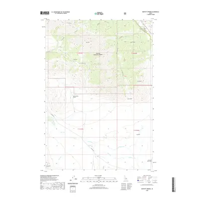
2020 Map of Moffett Springs
USGS Topo · Published 2020About this map
Moffett Springs and Barney Hot Springs anchor this high-elevation landscape where the Lemhi Range meets the Little Last River Valley. The transition from the steep, forested slopes of the Challis National Forest to the lower-lying Mud Flats is sharply defined, with numerous drainages like Big Gulch and Summerhouse Canyon carving through the terrain. The presence of geothermal features and various springs, including Iron Springs, suggests a complex hydrologic network that has long shaped land use in this part of Custer County. Transportation through the area is dictated by the topography, with Sawmill Canyon Road following the contours of Sawmill Canyon while the Pahimeroi Rd provides access to the western valley floor. The map also traces the county line between Lemhi Co and Custer Co as it crosses the high peaks near Iron Creek Point.
Find a feature on this map
32 named features on this map. Tap any name to fly to it.
Don’t see what you’re looking for? This feature index may not catch every label — zoom into the map to look around manually.
Map Details
Editions of this 2020 Moffett Springs Map
This is the sole edition of this map. No revisions or reprints were ever made.
Other maps of this area

1935 · Borah Peak
USGS Topo · 1:125,000

1938 · Borah Peak
USGS Topo · 1:125,000

1955 · Dubois
USGS Topo · 1:250,000

1956 · Donkey Hills
USGS Topo · 1:62,500

1957 · Gilmore
USGS Topo · 1:62,500

1957 · Hawley Mountain
USGS Topo · 1:62,500

1958 · Dubois
USGS Topo · 1:250,000
1967 · Short Creek
USGS Topo · 1:24,000

1987 · Gilmore
USGS Topo · 1:24,000
1987 · Mulkey Bar
USGS Topo · 1:24,000