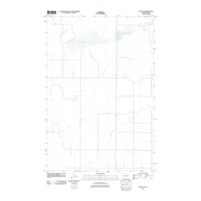
2011 Map of Moffit SE
USGS Topo · Published 2011About this map
Dutton Slough dominates the northern landscape of this Buchanan Valley Township region, where an intricate network of section-line roads defines the agrarian layout of Emmons County. The terrain is shaped by the subtle drainage patterns of Hawk Creek and Badger Creek, which meander through the prairie landscape before reaching larger water bodies like Long Lake Creek in the northeast. This 2011 survey illustrates the modern persistence of the Public Land Survey System, with roads like 55th St SE and 3rd Ave SE following the rigid geometry of township and range lines. The map reveals the characteristic wet-dry cycle of the North Dakota plains, where seasonal sloughs and creek beds serve as critical landmarks for local land management and hydrology.
Find a feature on this map
17 named features on this map. Tap any name to fly to it.
Don’t see what you’re looking for? This feature index may not catch every label — zoom into the map to look around manually.
Map Details
Editions of this 2011 Moffit SE Map
This is the sole edition of this map. No revisions or reprints were ever made.
Other maps of this area

1954 · Bismarck
USGS Topo · 1:250,000

1958 · Bismarck
USGS Topo · 1:250,000

1971 · Moffit SW
USGS Topo · 1:24,000

1971 · Hazelton
USGS Topo · 1:24,000

1971 · Moffit SE
USGS Topo · 1:24,000

1971 · Moffit NW
USGS Topo · 1:24,000
1971 · Hazelton NW
USGS Topo · 1:24,000

1971 · Moffit
USGS Topo · 1:24,000

1975 · Dana
USGS Topo · 1:24,000

1975 · Appert Lake
USGS Topo · 1:24,000