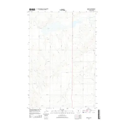
2014 Map of Moffit SE
USGS Topo · Published 2014About this map
Dutton Slough dominates the northern portion of this prairie landscape in Emmons County, marking a significant hydrologic feature in the Missouri Coteau region. The area is defined by its subtle drainage networks, where Long Lake Cr and Hawk Cr wind through the township's characteristic undulating topography. This 2014 survey records a strictly gridded rural framework of local connectors, including 56th St SE and 8th Ave SE, which delineate section lines and property boundaries across the open terrain. In the southwest, the headwaters of Badger Cr emerge, further illustrating the intricate water management of these North Dakota plains. The map reflects a modern rural landscape where the traditional township-and-range system remains the primary organizational structure for agriculture and land use.
Find a feature on this map
17 named features on this map. Tap any name to fly to it.
Don’t see what you’re looking for? This feature index may not catch every label — zoom into the map to look around manually.
Map Details
Editions of this 2014 Moffit SE Map
This is the sole edition of this map. No revisions or reprints were ever made.
Other maps of this area

1954 · Bismarck
USGS Topo · 1:250,000

1958 · Bismarck
USGS Topo · 1:250,000

1971 · Moffit SW
USGS Topo · 1:24,000

1971 · Hazelton
USGS Topo · 1:24,000

1971 · Moffit SE
USGS Topo · 1:24,000

1971 · Moffit NW
USGS Topo · 1:24,000
1971 · Hazelton NW
USGS Topo · 1:24,000

1971 · Moffit
USGS Topo · 1:24,000

1975 · Dana
USGS Topo · 1:24,000

1975 · Appert Lake
USGS Topo · 1:24,000