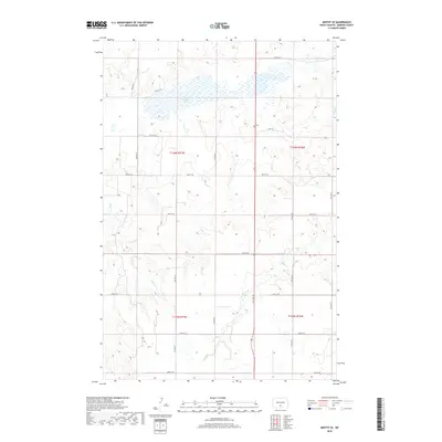
2018 Map of Moffit SE
USGS Topo · Published 2018About this map
Dutton Slough and the winding course of Long Lake Cr characterize this prairie landscape within Buchanan Valley Township during the early twenty-first century. The terrain is defined by a dense grid of section-line roads, including 3rd Ave SE and 60th St SE, which facilitate travel through the agricultural divisions of t136n r77w and neighboring townships. Several seasonal and perennial watercourses, such as Badger Cr and Hawk Creek, carve through the undulating topography, suggesting a drainage pattern typical of the Missouri Plateau. This 2018 survey by the U.S. Geological Survey provides a precise view of the rural infrastructure and natural hydrology that define this part of Emmons County.
Find a feature on this map
24 named features on this map. Tap any name to fly to it.
Don’t see what you’re looking for? This feature index may not catch every label — zoom into the map to look around manually.
Map Details
Editions of this 2018 Moffit SE Map
This is the sole edition of this map. No revisions or reprints were ever made.
Other maps of this area

1954 · Bismarck
USGS Topo · 1:250,000

1958 · Bismarck
USGS Topo · 1:250,000

1971 · Moffit SW
USGS Topo · 1:24,000

1971 · Hazelton
USGS Topo · 1:24,000

1971 · Moffit SE
USGS Topo · 1:24,000

1971 · Moffit NW
USGS Topo · 1:24,000
1971 · Hazelton NW
USGS Topo · 1:24,000

1971 · Moffit
USGS Topo · 1:24,000

1975 · Dana
USGS Topo · 1:24,000

1975 · Appert Lake
USGS Topo · 1:24,000