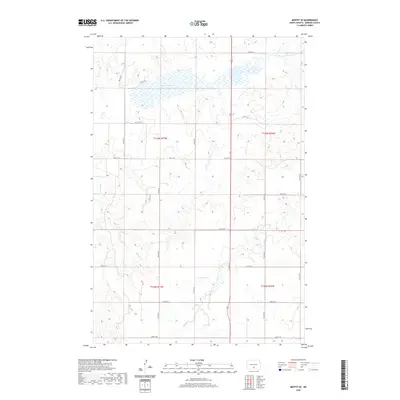
2020 Map of Moffit SE
USGS Topo · Published 2020About this map
Dutton Slough dominates the northern reaches of this Emmons County landscape, illustrating the characteristic prairie pothole topography of central North Dakota. The drainage patterns here are defined by several seasonal waterways, including the winding course of Hawk Creek and the distinct path of Badger Creek. The land is organized by an extensive grid of section-line roads, such as 55th St SE and 8th Ave SE, which facilitate the region's agricultural layout. These transit routes connect various townships, including t136n r77w and t135n r76w, providing a clear record of the rural property divisions and hydrology in Buchanan Valley Township as it appeared in the early 21st century.
Find a feature on this map
23 named features on this map. Tap any name to fly to it.
Don’t see what you’re looking for? This feature index may not catch every label — zoom into the map to look around manually.
Map Details
Editions of this 2020 Moffit SE Map
This is the sole edition of this map. No revisions or reprints were ever made.
Other maps of this area

1954 · Bismarck
USGS Topo · 1:250,000

1958 · Bismarck
USGS Topo · 1:250,000

1971 · Moffit SW
USGS Topo · 1:24,000

1971 · Hazelton
USGS Topo · 1:24,000

1971 · Moffit SE
USGS Topo · 1:24,000

1971 · Moffit NW
USGS Topo · 1:24,000
1971 · Hazelton NW
USGS Topo · 1:24,000

1971 · Moffit
USGS Topo · 1:24,000

1975 · Dana
USGS Topo · 1:24,000

1975 · Appert Lake
USGS Topo · 1:24,000