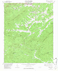
1982 Map of Moffitt Hill
USGS Topo · Published 1983About this map
The Catawba River flows through the northern reaches of this terrain where the Pisgah National Forest meets the scattered settlements of western North Carolina. In the early 1980s, the landscape here is defined by a dense network of country churches and family-named ridges, reflecting a deeply rooted rural community. Significant landmarks such as Mt Hebron Ch, Bethlehem Ch, and Salem Ch are clustered near the northern foothills, while smaller settlements like Lackey Town and Davistown occupy the valleys between Moffitt Hill and Jacks Mtn.
Find a feature on this map
81 named features on this map. Tap any name to fly to it.
Don’t see what you’re looking for? This feature index may not catch every label — zoom into the map to look around manually.
Map Details
Editions of this 1982 Moffitt Hill Map
2 editions found
Other maps of this area

1900 · Mount Mitchell
USGS Topo · 1:125,000

1902 · Mount Mitchell
USGS Topo · 1:125,000

1907 · Saluda
USGS Topo · 1:125,000

1934 · Parts Of Old Fort and Montreat
USGS Topo · 1:24,000

1935 · Montreat
USGS Topo · 1:24,000

1935 · Batcave
USGS Topo · 1:24,000

1935 · Black Mountain
USGS Topo · 1:24,000

1941 · Black Mountain
USGS Topo · 1:24,000
1942 · Montreat
USGS Topo · 1:24,000
1943 · Black Mountain
USGS Topo · 1:24,000