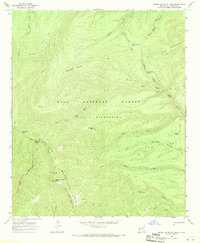
1965 Map of Mogollon Baldy Peak
USGS Topo · Published 1970About this map
Mogollon Baldy Peak dominates this high-altitude landscape, serving as a focal point for the surrounding Mogollon Mountains and the broader Gila Wilderness. The terrain is defined by a dense network of pack trails, such as the Crest Trail and McKenzie Trail, which navigate the steep drainage basins of the West Fork Gila River and Cub Creek. These routes connect isolated high-country features like the Mogollon Baldy Lookout Tower and the West Fork Corral, reflecting a landscape managed for fire observation and wilderness conservation within the Gila National Forest.
Find a feature on this map
35 named features on this map. Tap any name to fly to it.
Don’t see what you’re looking for? This feature index may not catch every label — zoom into the map to look around manually.
Map Details
Editions of this 1965 Mogollon Baldy Peak Map
2 editions found
Other maps of this area

1910 · Mogollon
USGS Topo · 1:125,000

1911 · Alum Mountain
USGS Topo · 1:125,000

1912 · Mogollon
USGS Topo · 1:125,000

1913 · Alum Mountain
USGS Topo · 1:125,000

1954 · Clifton
USGS Topo · 1:250,000

1957 · Clifton
USGS Topo · 1:250,000

1958 · Clifton
USGS Topo · 1:250,000

1962 · Clifton
USGS Topo · 1:250,000

1963 · Bearwallow Mountain
USGS Topo · 1:24,000

1963 · Negrito Mountain
USGS Topo · 1:24,000